


Structure of nodemaps
Navigating Maps
Natural Space
Fostering creativity


Home > Archive > Developers/reference > Finding information > Navigating Maps
![]()
People rely on maps to find things in the real world and consult, for example, subway maps or road maps. Maps are also a useful visualization of concepts. Navigating the Internet using current models can be like looking at a map through a cardboard tube, bereft of context. In real life, as people navigate the world, they see the objects near them in detail, while the periphery is small or beyond their sight (16).
Maps are well suited to show both real geography and concepts. While, today, maps are considered products of a rationalistic, scientific worldview, maps also have a mythic quality. Pre-modern maps, and mapping outside the Western tradition, often merge geography with non-scientific cosmography, showing the relationship of the viewer to the universe.
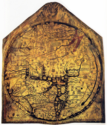
Historical example of a map with regions which are in part real and in part mythic: The Mappa Mundi shows Jerusalem at the center of the world, and attempts to accurately represent the world known at the time.
Medieval T-O maps, for example, show Jerusalem at the center of the world, and in some cases related the body of the Earth to the body of Christ. By contrast, navigational (or Portolan) charts of the Mediterranean from the same period are remarkably accurate. Also, maps of heaven/earth/hell have been developed from descriptions in such literary works as Dante’s Divine Comedy and John Milton’s Paradise Lost.
![]()
By design, maps are a symbolic representation of the physical world that seeks to help a person see in one’s mind the pattern of the signified space. The nodes of a map are actually avatars of the real objects (cities, scientific concepts, imaginary artifacts, etc.) that they stand for. The transition of node A to node B is a simulation of movement in the material world, which is used as a par excellence means of virtualization.
Contextual maps are relative to the viewer. Road maps are perhaps the most widely used maps today, and form a subset of navigational maps, which also include aeronautical and nautical charts, railroad network maps, and hiking and bicycling maps.
In contrast to an objective map or chart depicting a location, a contextual map shows the portion of the map relative to where the viewer is located. Static contextual maps are often used in transportation, such as in a subway or train station, and communicate where the person is standing (“You Are Here”) so that he or she may decide which route to take to arrive at the desired destination. Static contextual maps are often used in situations where a realistic map would be impractical.
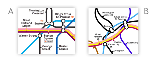
Figure 20. A. Classic example of a contextual map is the one designed by Harry Beck for the London Underground (Subway) in 1931. B. Contrast it with a geographically accurate rendering.
In 1931, Harry Beck’s task was to design a map (Figure 20) that made navigating the London subway easy for travelers. As the London Underground network is large and sprawling, a conventional geographical map would be rather confusing. (TFL, 2007; Clarke, 2000)
The process of contextualization makes the system easier to navigate. Because travelers underground are bereft of reference points and landmarks, it is far easier to navigate using the simplified conceptual framework of a contextual map.

